Ex-Hurricane Humberto Now Forecast to Track Closer to Ireland on Friday
Ex-Hurricane Humberto could bring Storm Éowyn-like conditions to Ireland on Friday.
Ireland faces a potentially significant storm on Friday as weather models show Ex-Hurricane Humberto tracking much closer to the country than previously forecast, with amateur meteorologists warning of conditions similar to Storm Éowyn. However, considerable uncertainty remains about the exact path and intensity.
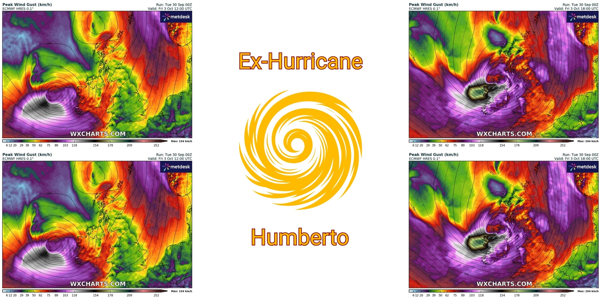
Overnight updates to weather models have shifted the forecast track of Ex-Hurricane Humberto substantially closer to Ireland, prompting warnings from amateur forecasters about the possibility of damaging winds across the country on Friday, 3 October. The European ECMWF model now shows what some are calling a worst-case scenario, with the storm centre passing near or over Ireland.
Nick Critch, Weather Alerts Ireland, said:
"The ECMWF model is now looking like the worst case scenario with a direct hit for Ireland on Friday! Looking similar to Storm Éowyn which is very concerning! High level warnings could well be issued!"
Storm Éowyn struck Ireland on 24 January 2025, bringing record-breaking wind gusts of 183 km/h at Mace Head, County Galway, breaking an 80-year-old national record.
Cork received a red weather warning and was affected by the storm, with around 20,000 homes and businesses losing power, trees falling in multiple areas including Cobh, Cloyne, Crosshaven and Killavullen, and wind gusts exceeding 130 km/h recorded at Roches Point and Sherkin Island. Nationwide, over 725,000 customers lost power, making it the most severe storm to hit Ireland since Hurricane Debbie in 1961.
Cathal Nolan, Ireland's Weather Channel, warned:
"A significant update in the weather models overnight now places the centre of Ex-Hurricane Humberto much closer to the northwest coast of Ireland with a swathe of damaging winds now increasingly likely on Friday, especially across Connacht, the Midlands and all of Ulster. Indeed the latest ECMWF pushes the windspeeds to a level not too dissimilar from Storm Éowyn."
However, the forecast remains highly uncertain, with different weather models showing significantly different scenarios. Whilst the ECMWF model depicts a severe storm passing close to or over Ireland, other models including the GFS show a direct hit but with weaker intensity, and the French Arpege and German ICON models keep the worst conditions further south and offshore.
Alan O'Reilly, Carlow Weather, cautioned:
"Still huge uncertainty on possibly stormy weather Friday. The latest weather model updates show some big changes with ECMWF showing the worst possible outcome now as other models keep the worst away from Ireland. Expect big changes on your weather apps."
Weather model guidance for Cork suggests Friday could bring heavy rainfall totals of 20-35 mm across lowlands and 35-60 mm over the Shehy and Caha Mountains, raising the risk of localised flooding. Wind gusts could reach 80-110 km/h in exposed areas if the storm tracks close to the county, particularly during Friday afternoon and evening.
The strongest winds and heaviest rainfall are expected to affect western and northwestern counties most severely, though the exact areas at risk will depend on the storm's final track, which remains uncertain.
Met Éireann's current forecast for Friday describes "a wet and windy day with widespread rain, heavy at times, accompanied by strong and gusty southerly winds" with temperatures of 16 to 18 degrees. The national forecaster has not yet issued any weather warnings for Friday.
The divergence between amateur forecasters' warnings and Met Éireann's current outlook reflects the significant uncertainty in how Ex-Hurricane Humberto will develop as it crosses the Atlantic. Weather models frequently disagree on the exact track and intensity of transitioning tropical systems, and forecasts typically become more reliable within 48-72 hours of an event.
For Cork, Friday afternoon and evening could bring difficult driving conditions with heavy rain and strong crosswinds, particularly on exposed routes and bridge crossings.
Storm Éowyn, which struck in February, caused widespread disruption across Cork with wind gusts exceeding 130 km/h in exposed areas, thousands of homes losing power, and significant tree damage blocking roads. If Ex-Humberto follows a similar track and intensity, similar impacts would be possible.
Please continue to monitor official forecasts from Met Éireann throughout the week, as the situation will become clearer over the next 24-48 hours. If weather warnings are issued, preparations should include securing outdoor items, checking property drainage, ensuring mobile devices are charged, and avoiding unnecessary travel during the storm's peak.
The public is advised to follow Met Éireann's official warnings rather than relying solely on amateur forecasts, as the national forecaster has access to additional data and expertise in issuing appropriate warnings.
Updates on Ex-Hurricane Humberto's track and potential impacts will continue to be issued as the system approaches Ireland.


