Meteorologists Commentary: Storm Bram
Met Éireann names Storm Bram as meteorologist warns of compound impacts from strong winds, heavy rain and high tides hitting Cork tonight through Tuesday.
Met Éireann has named Storm Bram, which will bring strong winds, heavy rain and high tides to Cork and southern counties from late tonight through Tuesday. With ground already saturated after a week of persistent rain, flooding is expected across the county.
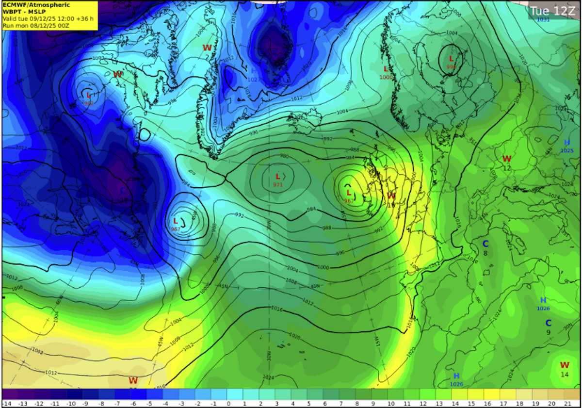
The Atlantic low-pressure system will deepen rapidly as it approaches the southwest coast tonight, bringing a spell of heavy rain followed by very strong winds. Cork faces a compound weather event, with the storm's impacts amplified by already waterlogged ground, rivers approaching bank-full conditions, and coinciding high astronomical tides.
Meteorologist Matthew Martin said:
"It's looking increasing likely that Ireland will experience some very inclement weather from Monday night and through Tuesday. A low-pressure system in the Atlantic is going to deepen fairly rapidly as it approaches the southwest coast on Monday night."
He continued:
"Given its evolving nature, we have issued a yellow wind warning for the entire country, followed by a set of orange wind warnings for southern and western coastal counties, as they are most vulnerable to the compound effects of the wind at high tide."
Met Éireann has issued a Status Yellow rain warning for Cork, Kerry, Tipperary, Waterford, Carlow, Kilkenny and Wexford, with heavy rain expected to fall on already saturated ground. The warning comes after a week of steady rainfall that has left soils across the county highly saturated and many rivers approaching capacity.
Met Éireann has issued a Status Orange wind warning specifically for Cork, Kerry, Waterford and Wexford, valid from 7am to 3pm Tuesday. Storm Bram will bring very strong to gale force southerly winds with the strongest winds along the coast. A Status Yellow wind warning remains in effect for all of Ireland from 6am to 9pm Tuesday.
Flooding and Coastal Risks
Surface and river flooding is expected throughout Tuesday and possibly Wednesday, even after the rain warning expires Tuesday morning, as rivers may take time to respond. The high tides will prevent river water from discharging to the sea, causing water to back up and significantly increasing the risk of upstream flooding along low-lying areas, especially across rivers in Cork, south Kerry, south Tipperary and Waterford.
High tide on southern and western coasts, including Cork, will occur early Tuesday morning between 7am and 9am. The combination of southerly onshore winds with very high astronomical tides and wave action will heighten the risk of coastal flooding. Surge levels will rise to 0.8 metres in some locations with significant waves forecast.
Matthew Martin warned: "Flooding impacts are expected as the rain will fall on already saturated ground and many rivers are currently approaching bank full conditions. We are in a period of high astronomical tides, which will coincide with the strong, potentially onshore winds, so there is high risk of coastal flooding."
He echoed the advice of the Irish Coast Guard: "Stay Back, Stay High, Stay Dry. The high tides will prevent the rivers from discharging to the sea, significantly increasing the risk of upstream flooding along low-lying areas."
Travel Disruption Expected
Very difficult travel conditions are anticipated for Tuesday morning's commute. Surface water, reduced visibility and strong winds may make driving hazardous and could lead to delays on roads, rail, ferry and air services. Motorists should allow extra time and take caution on exposed routes, particularly the N40, N22, N71 and other coastal roads.
Large waves may breach sea walls or coastal barriers, posing risks to people near shorelines and potentially impacting coastal infrastructure in exposed locations. Strong winds could lift unsecured items, increasing the risk of damage or hazards on roads and in public spaces.
Safety Advice for Cork Residents
The public should stay up to date with forecasts and warnings on met.ie, the Met Éireann app or Met Éireann social media channels. Allow for disruption during Tuesday morning's commute, plan extra travel time and reduce speed. Expect surface water, debris and poor visibility on Tuesday morning.
Keep away from coastal edges, harbours, piers and low-lying promenades during high tide. Stay back from riverbanks, streams and canals, as water levels may rise quickly. Keep children and pets away from waterways and flooded areas.
Do not try to walk, cycle or drive through flooded areas. Turn back and use another route. As little as 150mm of fast-flowing water can knock you off your feet, and 300mm can move most cars off the road.
Secure loose outdoor items ahead of strengthening winds tonight. ESB Networks is highlighting the dangers posed by fallen live wires and advising the public to stay away from fallen cables and report them immediately to ESB Emergency Services at 1800 372 999. The public can monitor power restoration times at PowerCheck.ie.
Uisce Éireann customers can check the website and social media channels for updates, contact their 24/7 customer care centre at 1800 278 278, or sign up online to their free text alert system at water.ie.
Storm Naming and Context
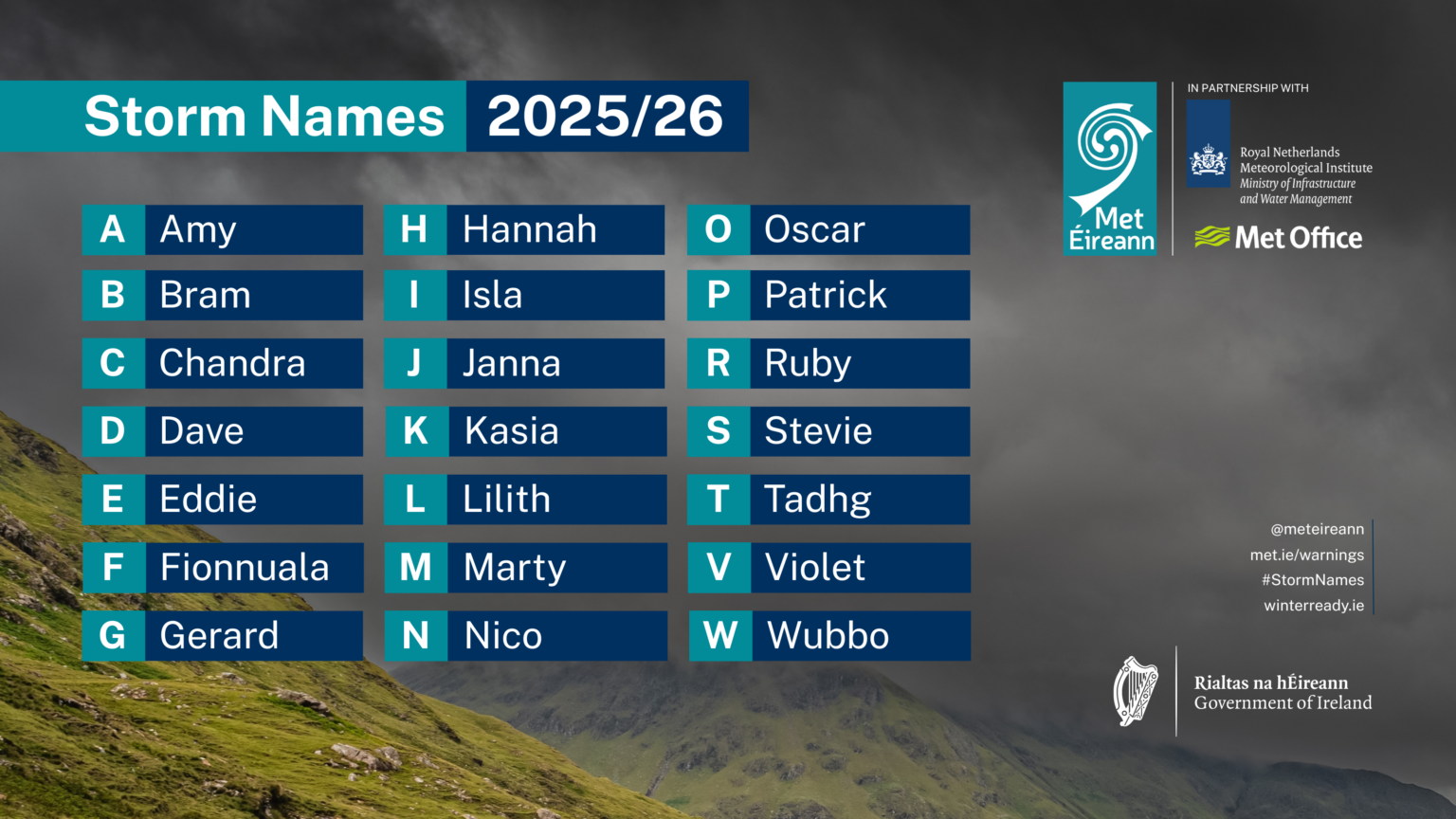
Storms are named when they could cause medium or high impacts. Since 2015, Met Éireann and the UK Met Office have worked together on the naming programme, joined by the Netherlands' KNMI in 2019. Storm names for the 2025/26 season include Amy, Bram, Chandra, Dave, Eddie, Fionnuala, Gerard and others, with Met Éireann calling on Ireland's public to submit preferred names through a social media campaign that received more than 10,000 submissions.
It is very common for Ireland to see named storms in winter, particularly in December. Only last year at this time, Ireland was impacted by Storm Darragh. Every year but one since the naming initiative started has seen named storms in December.
The warnings are likely to be updated as the situation evolves. Cork residents should keep in touch with Met Éireann's social media channels, met.ie and the Met Éireann app to stay up to date with the forecast and any warning updates.