Major Traffic Disruptions Expected as National Ploughing Championships Draws Over 80,000 Daily
National Ploughing Championships 16-18 Sept. Exit M8 at Junction 6 (Horse & Jockey). Follow Blue Route via Thurles-Templemore.
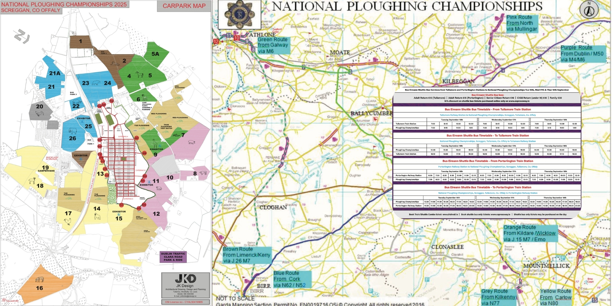
Gardaí have issued comprehensive traffic management plans ahead of the National Ploughing Championships, which runs from Tuesday 16th to Thursday 18th September 2025 at Screggan, Tullamore, County Offaly.
With over 80,000 people expected each day, significant road closures and diversions will be in place from 6am on Tuesday until 8pm on Thursday.
Key Road Closures and Restrictions
The N52 between Tullamore and Birr will face partial closure during the event. Local roads around Mucklagh village and the event site will also be closed to general traffic.
Road users not attending the championships are strongly advised to avoid the entire N52 corridor between Tullamore and Birr, as well as all approach roads to Mucklagh village.
Critical Warning: Avoid Sat-Nav Near Event Site
Gardaí are emphasising that drivers must not rely on satellite navigation or mapping applications when approaching the event site, as these systems may not reflect the temporary traffic management measures in place.
All attendees should instead follow the official colour-coordinated route system available at garda.ie, which provides specific directions based on journey starting points.
Cork and Munster Traffic: Blue Route
Traffic from Cork and Munster should follow the designated Blue Route. Drivers travelling northbound on the M8 must exit at Junction 6 (Horse & Jockey) and proceed through Thurles, where Gardaí will direct traffic towards Templemore and Roscrea along the N62.
From Birr, traffic joins the N52 travelling northbound via Kilcormac and Blueball to reach the event site. Blue Route users will park in designated blue car parks beside the event grounds.
Other Regional Routes
The traffic management plan includes eight colour-coded routes serving different regions. Dublin traffic follows the Purple Route via M4/M6 to Junction 5, whilst northern traffic uses the Pink Route through Mullingar and Tyrellspass.
South-eastern counties follow either the Grey Route (Kilkenny) or Yellow Route (Carlow), with specific instructions for navigation through Portlaoise and Mountmellick areas.
Traffic from Limerick, Kerry and the southwest follows the Brown Route via M7 Junction 26, whilst western traffic uses the Green Route via M6 Junction 6. The Orange Route serves additional areas via the M7.
Planning Your Journey
Full route details and an interactive map are available at garda.ie and npa.ie. The interactive mapping system works on any internet-enabled device and provides detailed navigation instructions for each colour-coded route.
The assistance of all road users is required to allow traffic to move freely to and from the event. Attendees are asked to listen to and comply with any direction by An Garda Síochána or stewards during the event.
Significant updates will be posted on An Garda Síochána social media channels throughout the three-day event.