Forecasters Monitor Potential August Storm Risk for Ireland
Forecasters tracking potential storm for Monday/Tuesday; latest models suggest worst impacts may track further north.
Three popular weather forecasters are tracking a possible storm system that could impact Ireland early next week, with northern counties potentially facing the strongest winds if the system develops as some models suggest.
Cathal Nolan from Ireland's Weather Channel, Nick Critch from Weather Alerts Ireland, and Alan O'Reilly from Carlow Weather all highlighted the risk in their Tuesday forecasts, though they stressed significant uncertainty remains about whether the system will materialise.
Cathal Nolan, Ireland's Weather Channel:
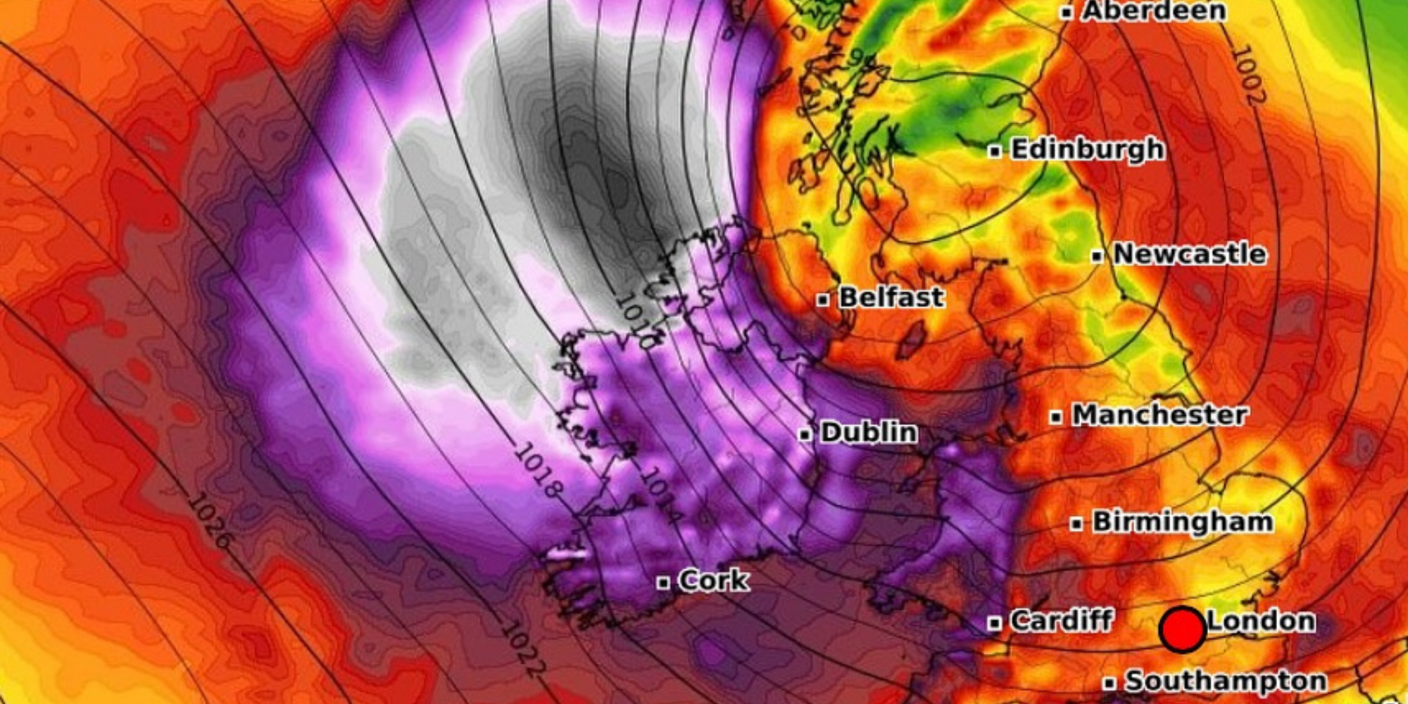
"The latest ECMWF, following on from a similar model run yesterday evening, indicated the risk of an early season storm through Monday night into Tuesday next, with northern areas most likely to experience the strongest winds should such a system develop."
Nolan emphasised this is not yet a forecast but rather an early indication that requires monitoring. He noted "massive discrepancies across the whole suite of models" approximately one week out from the potential event.
Nick Critch, Weather Alerts Ireland:
"The models are picking up on a storm possibly impacting Ireland on Monday into Tuesday next week! The GFS also shows a risk of a storm but time will tell if this will materialise."
Critch explained that the development would depend on how the low pressure system interacts with the jet stream, which is forecast to strengthen later this week. He confirmed he would continue monitoring the situation over the coming days.
Alan O'Reilly, Carlow Weather:
"Latest charts brings potential storm into Monday but further North with us missing worst of it. Going to be interesting to track this over the next few days."
O'Reilly's analysis suggests Ireland might escape the worst impacts if current model trends continue, with the storm potentially tracking further north than initially indicated.
In the meantime, Cork can expect relatively benign conditions. Met Éireann's forecast for Tuesday shows cloudy and misty conditions becoming mainly dry through the afternoon, with temperatures reaching 17 to 21 degrees in northwesterly breezes.
Wednesday will remain cloudy but mostly dry with temperatures of 19 to 21 degrees. The national outlook shows mixed conditions through the week, with the weekend looking particularly unsettled as a band of rain moves across the country on Saturday, potentially turning heavy at times.
Met Éireann has not yet issued any warnings regarding the potential storm system flagged by independent forecasters. Their extended forecast shows scattered showers for Sunday with temperatures remaining in the mid to high teens.
Both Nolan and Critch noted that between now and any potential storm development, Ireland will experience a slack west to northwesterly flow, leading to mostly dry weather with occasional mist and drizzle along Atlantic coastal areas.
Weather watchers are advised to stay tuned for updates later in the week as models become clearer about whether this early August storm system will develop and what track it might take across Ireland.